
OPEN
ALL LANES CLEAR
Last updated at: NOV 15, 2026, 5:56 AM PST · Caltrans
Live Caltrans status, chain controls, and cameras for the drive to Northstar California on SR-267, Truckee to Brockway Summit.

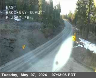
Hwy 267 at Brockway Summit
Tahoe Vista|landscape7,194 ft

Hwy 267 at Northstar
Northstar|landscape6,197 ft
Hwy 267 at Brockway Summit
Tahoe Vista · 7,194 ft
1 of 2
Truckee - Jct I-80 (aka - Bypass)
Truckee · 5,967 ft
Truckee Airport Rd
Truckee · 5,918 ft
Martis Creek
Truckee · 5,833 ft
Northstar Rd
Truckee · 6,200 ft
Kings Beach - (Jct. 267/28 - Stewart Way)
Kings Beach · 6,538 ft
Check Current Highway Conditions
This highway information is the latest reported as of Sunday, November 15th, 2026 at 05:56 AM.
IN THE NORTHERN CALIFORNIA AREA
No traffic restrictions are reported for this area.
Incoming storms, road conditions, and resort news, straight to your inbox.
For the whole highway, Truckee to Kings Beach, see the full SR-267 road conditions page.
The drive tops out at the summit: check Brockway Summit weather for current conditions and the forecast at 7,194 feet.
Check the live chain controls for every Sierra pass before you leave.
Read the chain guide for what R-0, R-1, R-2, and R-3 mean, and what to carry in the car.
Northstar California sits off SR-267 between Truckee and Kings Beach, and the drive climbs over Brockway Summit at 7,194 feet to get there. In a storm, that short climb is where chain controls go up first. The status above is the live Caltrans picture for SR-267, with the chain controls, the Northstar and Brockway Summit cameras, and the advisories for the drive below it.
Most drivers reach Northstar from I-80 at Truckee. SR-267 leaves the freeway on the Truckee bypass, crosses the Truckee River, and runs south through Martis Valley on a wide, modern two lane highway. About five and a half miles out, Northstar Drive turns off and climbs to the Village and the lifts. Notice what that means on the map: coming from Truckee, the resort turnoff sits on the valley side of the range, before the highway makes its real climb.
Chain controls are the fact of life on this road in winter, and Caltrans staffs five checkpoints along it: at the I-80 junction in Truckee at 5,967 feet, at Truckee Airport Road, and at Martis Creek at 5,833 feet on the valley floor, at Northstar Road at 6,200 feet by the resort turnoff, and at the SR-28 junction in Kings Beach at 6,538 feet. When a storm rolls in, the controls usually bite first on the high stretch around the summit, and the level at Northstar Road is the one that decides your drive to the lifts. The live list on this page shows each point with its current level; the chain guide explains what R-1, R-2, and R-3 ask of your car.
Brockway Summit itself tops out at 7,194 feet, and the summit camera on this page stares straight at that stretch of road. Drivers coming from Kings Beach and the North Shore climb three steep, curving miles from the lake side to reach it, then drop down past Northstar Drive toward Truckee. That is why this page watches the whole highway rather than one end of it: the same storm can leave Martis Valley merely wet and the summit in a full chain control, and the verdict above takes the worst of it.
Weather splits the same way. The Village at Northstar's base sits near 6,330 feet, more than 800 feet below the summit, so a morning that looks harmless at the resort can still mean snow and wind at the top, and a summit socked in by cloud can clear to a blue day at the lake. For the top of the climb, the Brockway Summit weather page carries the summit forecast; for the road itself, trust the live status and its Caltrans timestamp on this page over any forecast.
Parking is the last piece of the drive, and on the biggest days it is the piece that runs out first. Northstar Drive is the only road in and out, and traffic stacks up on it on powder mornings and holiday weekends. The Castle Peak lots, the first parking on Northstar Drive, are free every day and run a continuous shuttle to the Village, while the closer Village View lots ask for a reservation on weekend and peak mornings and the Preferred Paid lot sits by the gondola. Whatever the day, the pattern holds: the earlier you roll up Northstar Drive, the shorter the walk and the wait.
Before you leave, run the same three checks the locals run. First, the verdict at the top of this page and its Caltrans timestamp. Second, the cameras: Truckee Bypass for the valley, Northstar for the turnoff, Brockway Summit for the top. Third, the rest of your trip: if you came over I-80, the Donner Pass page and the Sacramento to North Lake Tahoe route cover the freeway leg home, and the chains page gathers every Sierra checkpoint in one list.
Is the road to Northstar open?
Right now, SR-267 over Brockway Summit is open with no chain controls posted (Caltrans, last updated NOV 15, 2026, 5:56 AM PST). Northstar is reached on SR-267 over Brockway Summit.
Do I need chains to drive to Northstar today?
Right now, SR-267 over Brockway Summit is open with no chain controls posted (Caltrans, last updated NOV 15, 2026, 5:56 AM PST). If the live page shows R-1, R-2, or R-3 at Northstar Road or anywhere on SR-267, follow that level. See the chain guide for what each level means.
Where are the chain control points on the way to Northstar?
On SR-267, Caltrans runs chain control points from the Truckee end of the highway through Northstar Road and up to Kings Beach. The live chain controls on this page show which points are active right now and the level at each one.
How far is Northstar from Truckee?
About five and a half miles south of the I-80 interchange in Truckee, SR-267 reaches Northstar Drive, and the resort road climbs from there to the Village. The full run of SR-267 from Truckee to Kings Beach is about thirteen miles. In clear weather it is a short drive; under chain controls, or in the storm day line on Northstar Drive, allow much longer and check the live status above before you leave.
Do I cross Brockway Summit to get to Northstar?
From Truckee, no: the Northstar Drive turnoff comes before the summit climb, so most Truckee drivers never cross the top. From Kings Beach and the North Shore, yes: SR-267 climbs from the SR-28 junction over Brockway Summit at 7,194 feet and drops to Northstar Drive on the Truckee side. Either way, the live status on this page covers the whole highway.
Which camera shows the road to Northstar?
Three Caltrans cameras cover the drive, and they are all on this page: the Truckee Bypass camera at 5,866 feet, the Northstar camera at 6,197 feet by the resort turnoff, and the Brockway Summit camera at 7,194 feet. Look at the summit camera for the worst of the weather and the Northstar camera for the road by the turnoff.
Is the weather at Brockway Summit the same as at the resort?
Often not. The summit sits at 7,194 feet and the Village at the resort base is near 6,330 feet, and that gap means the top can be in snow, wind, and chain controls while the resort is merely wet, or the other way around on a clearing day. The Brockway Summit weather page tracks the top; this page carries the live road status for the whole drive.
When do chain controls usually go up on SR-267?
Chain controls on this highway follow the snow, and the high ground goes first: the stretch from Northstar Road over Brockway Summit picks up controls before the lower Martis Valley floor does. Controls can also be lifted and reset within the same day as plows and conditions change. The live chain controls on this page show the current level at each checkpoint with its Caltrans timestamp.
Where do I park at Northstar, and do I need a reservation?
The first lots you reach on Northstar Drive are the Castle Peak lots, free every day with a continuous shuttle into the Village. Closer in, the Village View lots ask for a reservation on weekend and peak mornings, and the Preferred Paid lot sits closest to the gondola. The resort adjusts its parking rules by season, so confirm the current setup on Northstar's own parking pages before a big day.
What time should I leave for Northstar on a storm day?
Earlier than feels reasonable. On powder days and holiday weekends the line forms on Northstar Drive well before the lifts open, parking fills from the Village outward, and a chain control stop on SR-267 adds its own delay. Check the live status and the cameras on this page before you leave Truckee or Kings Beach, and if controls are up, build the chain stop into the plan.
Can I reach Northstar from Kings Beach and the North Shore?
Yes. SR-267 starts at SR-28 in Kings Beach and climbs over Brockway Summit straight to Northstar Drive, which is how most North Shore drivers reach the resort. That side of the highway is the high side, so its chain controls and the summit camera on this page matter most for the trip. The full SR-267 page covers the highway end to end.
Does SR-267 ever close completely?
It can, most often in the biggest storms, when spinouts, whiteout conditions, or debris work force Caltrans to hold or close the highway, usually near the summit. A closure here also changes the North Shore picture, because SR-267 is the direct link between I-80 and Kings Beach. The verdict at the top of this page shows a closure the moment the feed reports it.
What should I check before driving home from Northstar?
Check this page again before you leave the resort: SR-267 conditions can change between your first run and your last. If your drive home uses I-80 over Donner Summit, check that status too, because the two highways can be in very different shape on the same afternoon. The chains page gathers every Sierra checkpoint in one list for the full trip home.