
OPEN
ALL LANES CLEAR
Last updated at: NOV 15, 2026, 5:56 AM PST · Caltrans
Current conditions, the forecast, and the live road picture for Brockway Summit on SR-267, Truckee to Kings Beach.

Hwy 267 at Brockway Summit
Tahoe Vista|landscape7,194 ft

Hwy 267 at Northstar
Northstar|landscape6,197 ft

Hwy 267 at Truckee Bypass
Truckee|landscape5,866 ft
Hwy 267 at Brockway Summit
Tahoe Vista · 7,194 ft
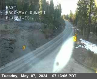
1 of 3
Truckee - Jct I-80 (aka - Bypass)
Truckee · 5,967 ft
Truckee Airport Rd
Truckee · 5,918 ft
Martis Creek
Truckee · 5,833 ft
Northstar Rd
Truckee · 6,200 ft
Kings Beach - (Jct. 267/28 - Stewart Way)
Kings Beach · 6,538 ft
Check Current Highway Conditions
This highway information is the latest reported as of Sunday, November 15th, 2026 at 05:56 AM.
IN THE NORTHERN CALIFORNIA AREA
No traffic restrictions are reported for this area.
Incoming storms, road conditions, and resort news, straight to your inbox.
For the full road picture on this highway, see the SR-267 road conditions page: the live status, every chain control point, and the cameras from Truckee to Kings Beach.
Headed to the resort? See Northstar road conditions for the live status and chain controls on the drive up from Truckee.
Check the live chain controls for every Sierra pass before you leave.
Read the chain guide for what R-0, R-1, R-2, and R-3 mean, and what to carry in the car.
Weather at Brockway Summit decides what the short drive on SR-267 looks like. The summit sits at 7,194 feet between Truckee and Kings Beach, so a clear morning in the valley can still mean snow, wind, and chain controls at the top. The live weather above and the road status with its Caltrans timestamp, the summit camera, and the chain controls below it give you the whole picture before you leave.
What is the weather at Brockway Summit right now?
The live weather section at the top of this page shows the current conditions for the Brockway Summit area, and the road status above it carries its Caltrans timestamp. Check the two together: the weather says what is happening in the sky, the status says what Caltrans has on the road right now.
Is it snowing at Brockway Summit?
Look at the Brockway Summit camera on this page and the current conditions in the weather section. If snow is falling at the summit, the camera shows it as it happens, and any chain controls Caltrans posts appear in the chain controls section below.
Is Brockway Summit open?
Right now, SR-267 over Brockway Summit is open with no chain controls posted (Caltrans, last updated NOV 15, 2026, 5:56 AM PST). Brockway Summit is the high point of SR-267 between Truckee and Kings Beach.