
OPEN
ALL LANES CLEAR
Last updated at: NOV 21, 2026, 3:56 AM PST · Caltrans

Hwy 80 at Donner Summit
Soda Springs|landscape7,221 ft

Hwy 80 at Castle Peak
Soda Springs|landscape7,165 ft

Hwy 80 at Soda Springs EB
Soda Springs|landscape6,692 ft
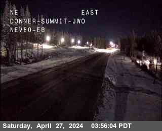
Hwy 80 at Donner Summit
Soda Springs · 7,221 ft
1 of 21
Applegate
Applegate · 2,020 ft
Applegate - End of Control
Applegate · 2,040 ft
Colfax
Colfax · 2,421 ft
Gold Run
Gold Run · 3,188 ft
Alta
Alta · 3,379 ft
Baxter
Alta · 3,897 ft
Drum
Alta · 4,333 ft
Drum (Whitmore)
Alta · 4,599 ft
Whitmore
Alta · 4,770 ft
Check Current Highway Conditions
This highway information is the latest reported as of Saturday, November 21st, 2026 at 03:56 AM.
IN THE SAN FRANCISCO BAY AREA - SOLANO CO
No traffic restrictions are reported for this area.
IN THE NORTHERN CALIFORNIA AREA & SIERRA NEVADA
No traffic restrictions are reported for this area. All westbound trucks are required to stop at the brake check area 0.5 mi west of Nyack (Placer Co) - To reduced the risk of brake fires
BUSINESS 80 - CAPITAL CITY FREEWAY
No traffic restrictions are reported for this area.
Incoming storms, road conditions, and resort news, straight to your inbox.
Planning your trip from the Bay Area to Lake Tahoe? Don’t get stuck in unexpected mountain traffic or chain control delays. At i80pass.com, we provide the most reliable, real-time I-80 road conditions to help you make informed travel decisions before you leave the Bay Area.
Mountain travel requires preparation. Whether you’re heading up for a weekend in North Lake or hitting the slopes, our site aggregates official Caltrans data to give you an instant status on the I-80 corridor. We strip away the noise so you can see exactly what is happening at the Donner Pass and beyond, ensuring a safer, faster trip from Northern California to the Sierra.
Check Before You Drive
Use our real-time status and camera feeds to monitor conditions at Donner Summit from your home in the Bay Area.
Chain Control Awareness
Avoid “surprise” delays by checking current chain requirements for the I-80 corridor before you hit the road.
Peak Traffic Monitoring:
Know when to leave. Use our real-time updates to gauge travel times and avoid the heavy Friday and Sunday rush.
Bookmark i80pass.com and keep us on your phone as your go-to source for I-80 road safety.
Real-time traffic, closures, accidents, and congestion updates.
Get the latest real-time road conditions for Interstate 80. From the Bay Area to Reno, we provide live traffic updates on closures, accidents, and congestion to ensure you reach your destination without unnecessary stress.
Chain controls, traction requirements, and winter travel alerts.
Prepare for the Sierra winter. Our I-80 portal tracks active chain controls and mandatory traction requirements. Always verify current road status before crossing the pass to ensure passenger safety.
Essential travel insights for the Interstate 80 corridor.
As the vital lifeline between California and Nevada, I-80 is your main route for Tahoe travel. We monitor this stretch 24/7 to provide the most reliable data for your commute or mountain getaway.
Plan ahead with live webcams, incident reports, and road updates.
Traveling I-80? Keep our site bookmarked for instant access to live webcams and incident reports. Knowing the conditions ahead of time is your best defense against peak traffic and hazardous weather.
I-80 is the main interstate route between the Bay Area and the Lake Tahoe region, crossing the Sierra over Donner Summit and continuing through Truckee toward Reno. For most Bay Area travelers, it is the default road to Tahoe, in summer and winter alike.
The drive changes character along the way. It starts as valley freeway, climbs through the Sierra foothills, then becomes a mountain highway where weather, grade, and traffic all matter more. The stretch over Donner Summit is where winter conditions bite hardest, and where chain controls and closures are most likely to affect your trip.
That is why this page pairs live conditions with a guide. The cameras and status above tell you what is happening now, and the guide below tells you what to expect along the corridor and how to prepare.
Winter storms can move in fast over the summit, and conditions at the top can be very different from conditions where you started. A clear morning in the Bay Area says nothing about the pass in the afternoon, so check conditions before you leave and check again while you travel.
Carry chains in winter even if no control is in effect when you leave. Controls can go up during your drive, and being caught without chains turns a manageable trip into a long wait at a checkpoint.
Keep your fuel tank topped up, and carry food, water, warm clothing, and a charged phone in the car. If traffic stops behind a closure or a chain control queue, you may wait a while, and mountain weather makes waiting uncomfortable fast.
Drive for the conditions, not the speed limit. Slow down, leave extra following distance, and avoid sudden braking or steering on snow and ice. If you are unsure, the safest choice is to wait out the storm rather than push over the summit.
When snow falls, Caltrans posts chain requirements for the I-80 corridor. The requirement level tells you what your vehicle needs to proceed, and it can change during a storm, so always confirm the current level on the live status above before you travel.
Requirement 1 (R-1): Chains or traction devices are required, except for passenger cars and light trucks with snow tread tires on at least two drive wheels.
Requirement 2 (R-2): Chains or traction devices are mandatory on all vehicles, except four wheel drive and all wheel drive vehicles with approved snow tread tires on all four wheels.
Requirement 3 (R-3): Chains or traction devices are required on all vehicles, without exception. Caltrans typically closes the high elevation portions of the highway during severe storms before R-3 controls are formally put in place.
Chain controls on I-80 are posted at checkpoint areas along the corridor, including Applegate, Colfax, Gold Run, Alta, Baxter, and Drum. If a control is in effect, expect slow traffic and queues near the checkpoints, and follow posted instructions and any directions from Caltrans or Highway Patrol crews.
If you do not know how to fit your chains, practice at home before your trip, not on the shoulder in a storm.
Donner Summit corridor: the pass itself is the biggest bottleneck. When weather closes lanes, meters traffic, or triggers chain controls, delays build here first and back up along the corridor. Check the summit cameras before you leave, not after you are already in the queue.
Truckee: this is where Tahoe bound traffic concentrates, especially traffic heading to North Lake and the town itself. Expect slower movement through Truckee on peak weekends.
Chain control checkpoint stretches: when controls are active, traffic slows and queues near the checkpoint areas. This is normal, not a sign of an accident, and it clears as vehicles are checked through.
Friday and Sunday patterns: Friday afternoon and evening carry the outbound weekend wave from the Bay Area, and Sunday afternoon and evening carry the return wave. Holiday weekends are heavier in both directions. If your schedule allows, traveling outside those windows is the simplest way to avoid the worst of it.
When I-80 closes: during major storms the highway can close at the summit. When that happens, do not try to find an unplowed shortcut. Wait for the official reopening and check this page for the current status. Other Tahoe routes, such as US-50 and SR-20, have their own conditions pages on this site, and checking them is worthwhile if I-80 is closed.
Summer brings its own delays: construction zones, heavy weekend traffic to the lake, and wildfire smoke that can reduce visibility. The same rule applies year round. Check conditions before you leave, and use the cameras to see what you are driving into.
If a wildfire is burning near the corridor, follow official evacuation and closure information first, and use this page for road status only.
Going over the top? The Donner Summit page goes deep on the summit itself: is Donner Pass open, the chain controls at Kingvale, Castle Peak, and Truckee, the summit cameras, starting with the Donner Summit camera at the crest, and summit weather.
Is I-80 open?
Right now, I-80 over Donner Pass is open with no chain controls posted (Caltrans, last updated NOV 21, 2026, 3:56 AM PST). The verdict block at the top of this page shows the same read for the I-80 crossing over Donner Pass.
Is Donner Pass open?
Right now, I-80 over Donner Pass is open with no chain controls posted (Caltrans, last updated NOV 21, 2026, 3:56 AM PST). Donner Pass is the summit of I-80, so that sentence is the Donner Pass status. The Donner Pass page goes deep on the summit stretch itself.
What are the road conditions on Donner Pass right now?
Right now, I-80 over Donner Pass is open with no chain controls posted (Caltrans, last updated NOV 21, 2026, 3:56 AM PST). The chain controls and webcams on this page carry the detail behind that read, checkpoint by checkpoint and camera by camera, updated as Caltrans reports them.
Do I need chains on I-80 today?
Right now, I-80 over Donner Pass is open with no chain controls posted (Caltrans, last updated NOV 21, 2026, 3:56 AM PST). If the posted level is R-1, R-2, or R-3, follow that level. The chains page shows the level at every checkpoint, and the chain guide explains what each level means.
Where is Donner Pass?
Donner Pass is the Sierra Nevada crossing of Interstate 80, between Sacramento and Reno. The highway tops out at Donner Summit, above 7,000 feet between Soda Springs and Truckee. This page carries the corridor wide answer for the whole drive, and the Donner Pass page goes deep on the summit stretch itself.
What is the weather on Donner Pass today?
The summit has a forecast of its own: the Donner Summit weather page carries the current conditions and the seven day forecast for the top of the pass, with an hourly view. The weather section on this page covers the towns the drive connects, Truckee, Tahoe City, South Lake Tahoe, and Incline Village, and the summit usually runs colder and windier than any of them. Read the forecast with the live status at the top of this page: the forecast says what is coming, and the status says what Caltrans has on the road now.
The pass makes its own weather. Donner Summit sits above 7,000 feet, and it can be snowing hard at the crest while Sacramento is dry and Reno is clear, which is why the summit gets a forecast of its own. Donner Summit weather carries the current conditions and the seven day outlook at the top of the pass, with an hourly view. The weather section higher on this page covers the towns the drive connects: Truckee, Tahoe City, South Lake Tahoe, and Incline Village. Check both before a winter crossing: the forecast for what is coming, and the live verdict at the top of this page for what is on the road now.